I’ve had a few discussions with people over the past week about geographic variation in disease risk. It’s a great subject because it’s an important and often overlooked issue. Whether it’s animals being imported, animals moving with their owners, animals accompanying owners on vacation or animals being moved between regions within the county, movement between regions can involve picking up or moving diseases at the same time.
From a veterinary standpoint, the challenge is identifying issues that you wouldn’t normally consider, because the disease is rare or non-existent in your practice area. The first step is querying travel history (which is done variably well). The next is figuring out what that means. We don’t have great resources that say “if you go here with your dog, this is what you need to be concerned about.” I get questions about travel risks all the time, and it’s taken a lot of effort to get up to speed with risks in different regions (and I still have a lot of gaps). We’ve published the odd (crude) map to help out, but getting good quality information, ideally based on surveillance data, and assimilating it into a central resource is a more significant challenge than one might think (a goal of ours, for sure, but a slow process given time and money limitations).
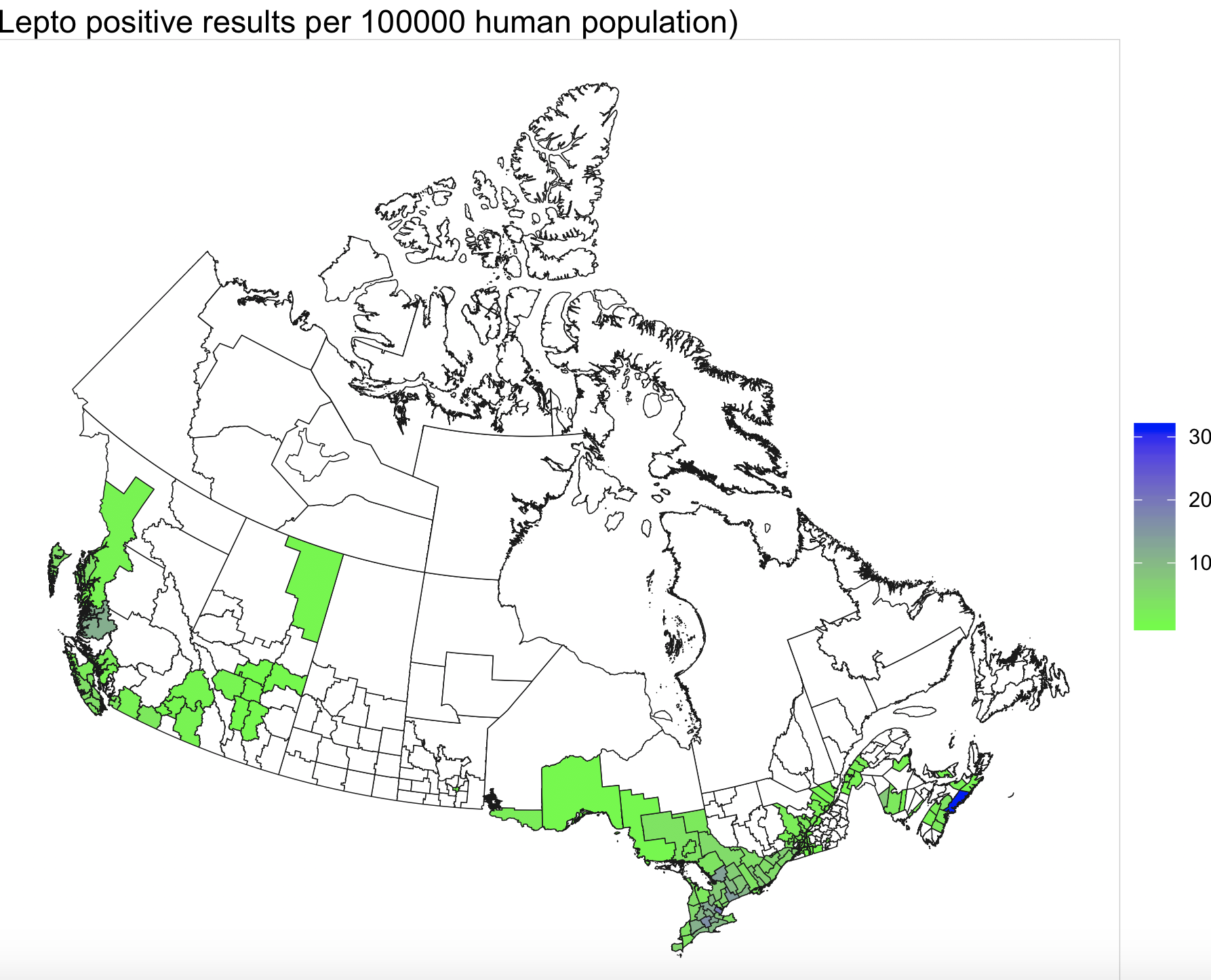
Regardless, we’re getting more information all the time and getting that out in the open is important. Dr. Michelle Evason wrote a post on her K9 Lifetime Study blog about the leptospirosis data we’re working on, and I thought that was worth putting up here too. It’s a fairly high level map of a few years of leptospirosis cases in dogs in Canada, based on data from IDEXX Laboratories. There are limitations with any dataset of this kind, so it’s not a perfect representation of this disease. However, it still provides some useful information. Lepto is a nasty disease and also a vaccine-preventable disease. So, understanding where it’s common is important for thinking about it when you have a sick dog (i.e. making a diagnosis) and discussing vaccination programs.
The incidence is adjusted for human population, on the assumption that dog ownership trends are similar across the country. We do that so that we don’t see bias towards big cities. If we just plot the number of cases, places with a big dog population but low incidence of disease could have more cases than a true high risk area with a lower population, thus hiding the real risk.
This bacterium lives in different wildlife hosts (e.g. raccoons, rodents), is passed in their urine, and survives well in moist, temperate climates. Unsurprisingly, we see lepto concentrated in much of Ontario and east of here, particularly in southern regions, as well as coastal British Columbia. Risks vary within those regions too, and lepto vaccination discussions require some assessment of other risk factors as well (although I consider lepto vaccination a core vaccine in most of the green (and all of the blue) regions on this map).